The passage was pretty good from Walvis Bay, Namibia to
St. Helena. It took us almost exactly 8
days and only the first day and a half was bumpy. The rest of the trip had less than 2 meter
seas and 15 to 20 knots from the aft port quarter. We had our sail up and
secured off to starboard and it stayed filled the whole time. I’m still not sure how much it helps, but any
fuel saved is always welcome.
We ran the water maker on day one and filled 2 of our 4
tanks, but on day three the water maker refused to start and is still not
running. We changed to showers every
other day and arrived with some water in our last tank. Since arrival, we have been sightseeing and
doing normal engine maintenance and using borrowed jerry jugs to fill our
tanks. Since we hold about 300 gallons
with all tanks full and water here is free, Tom has not been too worried. Even if we can’t get it working again, the
300 gallons will last through our upcoming 12 day passage to Brazil where we
have reservations at a marina dock.
We also have not been able to send in position reports
with our SSB radio. Other boats are
reporting the same problem, so we are hoping it’s a propagation problem rather
than something wrong with the radio. I
back-filled a couple of red dots after our arrival at Yoetreps.
There were no fireworks. There was no parade. And we
didn't keelhaul anyone. But along this passage we crossed the Prime Meridian,
that line on the globe that divides the eastern and western hemispheres. It is
just a line on a map, but being back in the Western Hemisphere makes us feel
like we are that much closer to home.
We arrived in Jamestown harbor at 9AM and picked up one
of their brand new 50 ton moorings.
Customs and the harbormaster officials came out to the boat to welcome
us and to fill in some paperwork. We had
to check in with Immigration on shore since one of the two staff members took a
day off.
The only way ashore is with a small ferry boat that drops
off at a concrete jetty for £1 each way.
At the jetty, the water swirls and rises and falls about six feet. At the edge of the jetty there are four or
five 1.5” diameter knotted ropes hanging down.
As the boat nears the jetty, you wait for the surge to raise up the boat
and at the top of the swell you grab the rope and swing ashore as the boat
drops away below your feet…not for the faint of heart! This was made even more interesting as we
made about 10 trips with 5 gallon water jugs!
St Helena has a fascinating history. The eroded remains
of a long extinct volcano on the middle of the South Atlantic, it was
discovered by the Portuguese back in 1502, but after a couple of hundred years
of the usual colonial shenanigans the island ended up in British hands. In
sailing days, it was a vital link for ship trade and over a thousand ships a
year stopped there for water and food, keeping several thousand inhabitants
busy farming and guarding the island. Its isolation and fortifications made it
the ideal spot to host Napoleon Bonaparte after his defeat at the battle of
Waterloo although that period only lasted for six years until his death in
1821. Subsequently, the island was used to house a number of prisoners
including 6000 Boers, a Zulu chief and a pair of Arab princes.
With the coming of steam driven ships, the importance of
the island as a resupply point declined so the island started a flax industry
for manila rope and linen. Again, the islanders' luck ran out with the coming
of synthetic fiber ropes and cloth. The final straw was when the Royal Mail,
the sole customer for parcel string, decided to go synthetic in 1966 leaving
the islanders with only a small amount of tourism, sales of stamps and a few
fish.
Now, the four thousand islanders are largely supported by the UK
Government which also funds the sole method of commercial access to the island
in the form of the elegant Royal Mail Ship St Helena as there is no airport on
the island. The "RMS", as she is known, sails on a regular route from
Cape Town to St Helena to Ascension and back about once every two weeks. She
brings in shipping containers of whatever is needed, the mail and most vitally,
passengers. This is the only way on and off the island for the locals and any
intrepid visitors. However, the winds of change are bearing down on the island
as the UK Government has decided to fund a £200 million airport in an effort to
make the island self-sustaining with tourism. This, as you can imagine, is a
matter of immense import to the islanders and a subject of much debate. The
airport is scheduled to be complete around 2016.
We enjoyed the once-a-week rush into Thorpes where the locals push and shove for fresh fruits and vegetables that come from the local gardens. We gave the locals a head start but still ended up with lettuce and cauliflower.
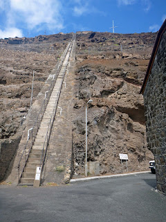
Jamestown and the harbor are at the bottom of a very
steep and deep valley but there are more dwellings at the top of the southern
valley side. Back in the days before the introduction of the internal
combustion engine, the easiest and quickest way between the two areas was a
steep ramp up which carts were pulled by a donkey powered windlass. These days,
the 699 steps of Jacob's ladder are just used by foolhardy tourists to test
themselves. The time record is 5 minutes 30 seconds and we have yet to find the
gumption or desire to climb it.
After exchanging some American dollars for British pounds
(£), we enjoyed a lunch at Annie’s and used the internet to send a S.O.S. to
the water maker service guys. We also
made arrangements to take an island tour with the crew of Theis.
When Napoleon first arrived on the island with his
entourage of 28 he was shown his proposed accommodations. I guess they
weren’t to his liking; it was a converted barn in much need of renovations.
On his way back to town he glimpsed a house and requested to be allowed
to see it. The owner graciously offered the front room to him, while his
permanent residence was being fixed.
The first house where he lived for 6 months is
situated overlooking the harbor with gardens surrounding it. We were shown the
front room and told that he lived there with one general interacting with the
family that owned the property and lived in a nearby home. He also had a tent that
was erected on the front lawn so he could rest there in the shade. It was unclear to me why they afforded so
much freedom to a prisoner. We were told
that the British gave him the rank of General with all the accordant privileges.
We then drove to Longwood House, the damp home in which Napoleon resided at the time of his death. During the long, boring years of his exile on the island, the diminutive emperor apparently spent much of his time laying on a chaise, reading, or soaking in a tub, reading. In his more active moments, he channeled his energies into designing and constructing classical gardens around Longwood House. We finished the house tour and wandered a bit around the gardens.
The last Napoleonic stop on our tour was his tomb, which
is nestled in a lush, green garden. Because the English (who referred to
Napoleon as "General") and the French (who referred to him as
"Emperor") could not agree on an inscription, the tomb is unmarked. This
is kind of poetic, as his bones have long since been relocated to France. Today
the garden contains a grove of banana trees, a couple of majestic Australian
pines and a fence surrounding a blank tablet marking an empty grave, over which
the French flag occasionally hangs limply in the humid air.
We also saw the ongoing airport construction site, a
secondary school, several forts surrounding the harbor, and the top of Jacob’s
ladder. The Governors’ Plantation House mansion
was impressive and we said hello to 181 year old Jonathan, the oldest
Seychelles tortoise in the world.
All around, this island was a nice stop. The locals speak English and could not have
been friendlier. Emily could check out
books at the local library and we all swam in the Olympic-sized fresh water
swimming pool for £0.70 each. Since
there are no cell phones, it was nostalgic to see the old style phone booths
that were quite busy. We found free
water to fill up our tanks and even a local boat to pump about 1600 liters of
diesel directly aboard.
After staying about
a week, we decided to make the 12 day passage to Recife, Brazil. There we hope to stay at a marina for about 4
weeks before moving North.
Tom


