Tuesday, March 22, 2011

Kawau Island


Kawau Island is another island in the Hauraki Gulf.  The island is named after the Māori word for the shag (cormorant) bird. 
Copper was mined on the island after discovery in the 1842, in the first years of European ownership. With imported miners and their families from Wales and Cornwall, the mining settlement finally reached a maximum of around 300 people, before problems with shipping and mine flooding (despite the construction of a pump house) closed the mine again in 1885. The island was bought a few years later by Sir George Grey, Governor of New Zealand, in 1862 as a private retreat. In 1856 a large quantity of gunpowder was stolen by Hauraki Maori from the Island. Grey extended the original copper mine manager's house (built 1845) to create the Mansion House, which still stands, and made the surrounding land into a botanical and zoological park, importing many plants and animals. The house changed hands several times after Gray, and decayed increasingly, but has been restored and furnished in the period of Governor Grey and is now in public ownership in the Kawau Island Historic Reserve, administered by the New Zealand Department of Conservation. The reserve is public land and covers 10% of the Island, and includes the old copper mine.
 
We pulled into Mansion Bay and anchored in calm waters 200 meters in front of the Mansion House.  We went ashore and met the park rangers and looked over the grounds and found the trail heads that we would later walk.  We also drove our dingy around to another bay to see the Kawau Island Yacht Club.  They had a nice dock and offered breakfast, lunch and dinners if you check ahead.

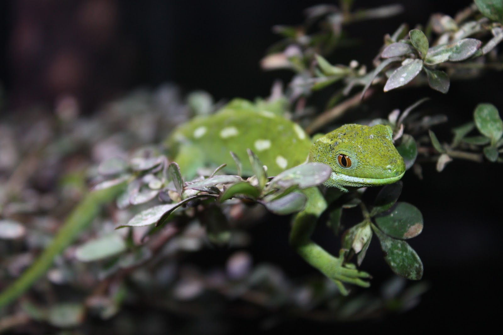
The island is home to kiwi and two thirds of the entire population of North Island weka (a ground bird). Among the animals that Grey introduced were five species of wallabies. Three of the six introduced wallaby species remain and do considerable damage to the native vegetation, thus harming the habitat for these flightless birds and other native fauna. The wallabies destroy all emerging seedlings which means that the present native trees are the last generation. The usual understorey forest species are absent due to wallaby browsing and in many cases the ground is bare.

 
The next morning we got up early and hiked the Lady’s bay and Coppermine tracks to see the old copper mine.  There is not much left except a large chimney and a few mines that go in about 25 feet before that have been sealed off for safety. 


We returned to the anchorage by the Redwood Track which goes through a grove of these mighty trees.  We got up early since both the Kiwi and Wallaby are nocturnal and we hoped to see them.  Sure enough we saw two wallabies ahead on the trail and got close enough for some good pictures of these and two more we saw later in the day.  No Kiwis were spotted but we saw many of the weka birds, some Paradise Ducks and more Oyster Catchers.


After doing all the park trails, we moved the boat over to Schoolhouse Bay and enjoyed that area.  We made the short dingy ride to the Yacht Club, had some meals there and bought a few items at their small store.  This is where we were anchored when the Japan earthquake and resultant tsunami washed into the bay.  Other than some swirling currents caused by the waves rushing in and out and some discolored water from stirred up sediment, we were unaffected.  We spent a few lazy days enjoying the calm anchorage and whittling away at home school lessons.

Tom

Friday, March 18, 2011

Auckland

We decided to splurge and spend some time at a marina since anchoring options were limited near this major city. We went into Westhaven Marina based on a local recommendation, but were disappointed at the 40 minute walk to downtown. The rain made the walk even less enjoyable and we soon started using taxis and busses to get around.


The skyline is dominated by the needle-shaped skytower. At 328 metres, it is the tallest man-made structure in New Zealand and offers breathtaking views for up to 80 kilometres in every direction. You can get clipped into a safety harness and walk around a platform above the city or (almost) bungee jump from the top. I say almost since you are attached to 3 separate wires during the jump and your fall is decelerated as you fall and gently braked at the bottom. We would have liked to go to the top and see the view but at almost a $100, it seemed like a waste of money to this tourist family. We saw much prettier views (than a city) for the cost of a 30 minute hike on many of the islands we visited so far.

We did go to the famous Auckland museum and the Auckland Zoo and found both to be well worth the effort to visit them.

The Auckland museum houses a large collection of Maori and Pacific Island artefacts and treasures, including for example three entire buildings, including Hotunui, a large carved meeting house built in 1878 at Thames, and Te Toki a Tapiri, a waka taua (war canoe) from 1830. The museum also stores a photographic collection of 1.2 million images, and stores and exhibits 1.5 million natural history specimens from the fields of botany, entomology, geology, land vertebrates and marine biology. Its collections concentrate on New Zealand history (and especially the history of the Auckland Region), natural history, as well as military history. The museum also shows the now extinct giant flightless bird, the Moa, that last great Maori war canoe used in battle, and two authentic World War II aircraft, a Mitsubishi Zero and a Packard Merlin Mark XVI Spitfire.


The Auckland Zoo is a 40-acre zoological garden. It has New Zealand's largest collection of animals and is recognized as one of the most progressive zoos in the world. A winner of national and international environmental-related awards, it is home to 117 different species and over 700 animals. Most of the larger animals are contained within moated, barless, naturalistic enclosures that are very spacious.


After 4 days we all had enough of the big city and pointed the bow north to explore a small island that was rumored to have wild wallabies hopping around. The crew of Emily Grace could not pass up that opportunity and, Dear reader, you will have to stay tuned to find out if we actually saw any of these kangaroo-like macropods.

Tom

Wednesday, March 16, 2011

Waiheke Island

Our next stop after conquering the Coromandel was Waiheke Island. This island is just offshore from Auckland and offered many protected bays from every wind direction. The island has several well known wineries and we hiked among them and stopped every so often for a taste test ?or two. Many of the vineyards were also growing olives and making olive oil. Our first anchor stop was Hooks Bay on the Northeastern tip where we found Stony Batter.

Stony Batter was of part of a counter-bombardment battery system progressively being installed in the Hauraki Gulf from the 1930s. Composed of various gun batteries, as well as having observation posts, it was supposed to engage enemy naval forces entering the inner gulf. Next to the gun pits there are 1000 feet of tunnels. These connected the gunpits with each other and with their ammunition stores, a plotting room, an engine room providing electricity, as well as with storerooms and barracks.


The tunnels and underground chambers were quarried by hand, with formwork for the walls and ceilings, then filled with concrete (reinforcing steel was not used due to shortages). Aggregate was obtained from the prominent rocky outcrops, giving Stony Batter its name.


While approved in 1939, construction was delayed for cost reasons until German raiders were sighted in New Zealand waters during 1940-1941, as well as the war entry of Japan in late 1941, suddenly turned it into a high-priority project. As the tides of war turned, only two guns were installed, one in 1944, and one in 1948. The third gun was cancelled before shipment. Never fired except for testing and training purposes, the guns were dismantled and sold for scrap in 1961.


The guns installed at Stony Batter were 9.2-inch (the shells they fired were 9.2" in diameter). Each gun weighed 110-120 tons and its turret had 2-inch steel armour-plating. The barrels weighed 28 tons; they were 442.75" long, and 34.75" in diameter at the breach end. The guns were mounted in concrete pits 40 feet in diameter. A 9.2-inch gun could fire two shells a minute once the crew were trained and if its electricity and hydraulics were working. They could be operated manually; then the maximum rate of fire was a shell every two and half minutes.

We had read about the tunnels and came with strong flashlights to explore on our own. Since we hiked up from the boat, we entered the tunnels near the guns and exited where they were collecting entry fees and passing out flash lights. Oh well, more money for the college fund!

We next moved around to Putiki bay and hiked to Ostend and then took a bus to Onetangi for lunch. We ate at The Beach Front Café and had one of the better meals we've had here so far.

From Waiheke we could see the Auckland skyline, so we voted to check that out next.

Tom

Friday, March 11, 2011

Japan Tsunami- Emily Grace is Safe

We were just finishing up our math lesson 2 hours ago when the captain noticed swirling brown water around the boat. Several of the boats were swinging randomly on their anchors here in Kawau Island and I even had the crew come out and look around at what I thought may have been the (a strong) changing of the tide.

It wasn't until that I took the dingy over to the local yacht club for gas and some milk that I learned of the devastating earthquake in Japan and the resultant tsunami sweeping over the Pacific. Other than the swirling brown water, that has now stopped, we saw little impact and are all fine and safe.

Our hearts go out to those in Japan, but we shudder to think about the small islands in the Pacific that were a mere two meters (6 feet) high. The tsunami wave surely must have swept completely over those islands affecting the people we met and have touched our lives. Our prayers are with them. I read that this quake was 1000 times more powerful than the quake that hit Christ Church in the south island 2 weeks ago and had caused so many deaths there.

Hugs to all,

Tom
Posted via SSB

Thursday, March 10, 2011

Whitianga and the Coromandel Peninsula


We were glad the kind NZ folks aboard Evening Star had offered us their mooring right off the Whitianga Harbour. Whitianga is a nice town and we enjoyed strolling through the shops and sipping over-priced coffee. We did some provisioning in the stores and toured the local museum. Emily got to try her hand at bone carving and did a nice job on her fish hook. The fish hook is called Hei Matau in Miori and (among other things) signifies safe passage over water which we can always use more of. We had the "school" to ourselves and the owner even explained to us how to do it straight from the cow bone. We now have a couple of cow bones drying aboard Emily Grace and will add bone carving to future craft days at the Lawler Academy of the High Seas.


The current was screaming past our mooring at 3 to 4 knots and I would have felt uncomfortable leaving the boat on anchor with these swift tides changing direction every 6 hours. As it was, we rented a car and had a whirlwind couple of days. The first evening we drove to Thames, a town on the southwestern corner of the Coromandel Peninsula and had dinner at a fish and chips place overlooking the Firth of Thames (bay). We drove up along the west coast to Coromandel town and enjoyed the views and NOT WALKING. We just made it back to the boat at sunset and rested up for the busy day ahead.

We started the next day with a visit to the Twin Oaks Ranch and Emily and I enjoyed a 2 hour horseback ride. Kim still had the painful memories of bareback riding in Tonga and opted out of this ride. The trek took us over expansive farmland, through beautiful native bush and streams and included a stop at a waterfall. We saw breath-taking views of Mercury Bay, Matarangi, Whangapoua, Great Barrier Island and the Pacific Ocean. My horse was well behaved and we were allowed to move off the trails a bit since it was just Emily, the guide and I. Emily did take one tumble as we charged up a hill, but was back in the saddle in a flash and nothing but her pride was damaged.


The car then took us to Coromandel town where we had lunch and found the Driving Creek Railway. Track laying began in 1975 by Barry Brickell shortly after he established a pottery workshop on land he purchased in 1973. As a railway enthusiast, he saw the practical and environmental advantages of having a narrow-gauge railway system through his rugged scrub-covered land to give all weather access to clay and pine wood kiln fuel. Brickell worked for 15 years and poured a considerable amount of money into railway construction before it was licensed to carry fare-paying public in 1990. The 1 hour round trip on the train took us through replanted native kauri forest and included 2 spirals, 3 short tunnels, 5 reversing points and several large viaducts as it climbed up to the mountain-top terminus. They called the building at the top the "Eyefull Tower" and it did offer great views out over the island-studded Hauraki Gulf with the forested valley and mountains behind.

We zipped back east across the peninsula and saw where Captain Cook observed the transit of Mercury and then to Hot Water Beach. We had read about Hot Water Beach and had to see it for ourselves. Volcanic vents bring hot fresh water up under the sand right on the white sand beach. When the tide is high, the hot water mixes with the cold seawater and is barely noticeable. However, low tide is when to come and we timed our arrival along with about 100 other crazy people. Whole families come with shovels and dug Jacuzzi-sized holes in the beach. The hole fills with 120 degree water and just before it becomes unbearable, a waves washes in with 65 degree water to cool it down. The wave recedes and the Jacuzzi heats up until the next wave. Much fun and Emily almost burnt a tender foot.

Exhausted, we turned in the rental car and slept soundly aboard Emily Grace wondering what we will find next as we continue to explore the Hauraki Gulf.

Tom

Tuesday, March 8, 2011

Great Mercury Island & Captain Cook

We left Great Barrier Island and made the mistake of going through the Coville Channel to Great Mercury Island with the tide opposing about 25 knots of wind. This thin bit of sea between Great Barrier and the Coromandel peninsula has swift currents and is known for its rough seas. We had steep waves, a sick captain and a salty boat upon arrival.

 
Most of Great Mercury Island is owned by a few very wealthy people and we anchored and used moorings right off their mansions and enjoyed "borrowing" their internet. We watched helicopters and beautiful motor launches come and go.

 We did go ashore and hiked around to see the sheep, cows and horses and the sweeping views. Emily loved running up and down the green hills and peering over the vistas.

We headed south into Mercury Bay and passed Cooks Bay into Whitianga. You guessed it, more captain Cook. Captain Cook and astronomer Charles Green observed the transit of Mercury at Te Whanganui-a-hei (Mercury Bay) on the Coromandel Peninsula.  On the way we passed Needle Rock.  Even with my old eyes, I could thread a needle through that hole!


The inner planets, Mercury and Venus, occasionally pass across the Sun and can be observed as small black dots. Timing these 'transits' from different locations on Earth was the first accurate method of determining our distance from the Sun.

Captain James Cook and his expedition members had recently been in Tahiti to observe the transit of Venus, and were now on a mission to search for the rumoured 'Great Southern Continent'. When stormy seas caused damage to the Endeavour, Cook turned his course towards the land discovered by Dutch seafarer Abel Tasman in 1642. On 6 October 1769, Nicholas Young the cabin boy spotted the East Coast of the North Island.

Over the next few months Cook mapped the entire coastline, providing the first-ever 'outline' of New Zealand - and establishing that it was not the Great Southern Continent. His charts proved so accurate that some were still being used in the 20th century.

Much of Cook's surveying was done from offshore, but as 9 November approached he sought solid ground from which to observe the transit of Mercury. The observation was made using the cutting-edge technology of the time, a sextant (invented in 1757). Cook was accompanied by Charles Green, the Royal Society expedition astronomer who died on the homeward journey in 1771.

Cooks Bay
From Cooks journal - "my reasons for putting in here were the hopes of discerning a good harbour and the desire I had of being in some convenient place to observe the Transit of Mercury, which happens on the 9th instant and will be wholly visible here if the day is clear between 5 and 6 o'clock." Cook also named the Whitianga Harbour "River of Mangroves" and this area is still referred to as "The River".

The sighting of the Transit of Mercury is commemorated on Cooks Beach by a cairn of Coromandel granite which tells the story ; "In this bay was anchored 5 Nov 1769, HMS Endeavour, Lieutenant James Cook RN, Commander. He observed the transit of Mercury and named this bay."

The Cook Monument
The next transit of Mercury that will be fully visible from New Zealand will occur in 2052.

Tom